Examining the claims of Jonathan Neville and the Heartland movement

Showing posts sorted by relevance for query "moroni’s america - maps edition". Sort by date Show all posts

Sunday, August 25, 2019

Those who live in glass houses, pt. 2

(Part two in what may become a series. See Part 1.)

Jonathan Neville has an entire blog—it’s just one of the sixty-six blogs he currently maintains—dedicated to criticizing publications by The Interpreter Foundation. (And Neville complains that Daniel Peterson “keeps mentioning” him online!)

In a post published August 24, 2019, Neville mocked a misspelling in The Interpreter Foundation’s 501(c)(3) filing:
Maybe they reject the teachings of Joseph Smith that they don’t like because they’re actually focused on Jeseph Smith:
501(c)(3) filing of The Interpreter Foundation
What’s ironic about this is that here we have Jonathan Neville making fun of Interpreter for misspelling a word, when Neville’s own publications are filled with misspellings, poor grammar, and incorrect punctuation.

Here are just a few examples from Moroni’s America − Maps Edition, written by Rian Nelson and edited by Jonathan Neville:
Moroni's America - Maps Edition forward
The “forward” [sic] to Nelson & Neville’s book. (p. iii)
Moroni's America - Maps Edition Rian Nelson's testimony of the Bok of Mormon
Rian Nelson has a testimony of the “Bok [sic] of Mormon.” (p. iii)
Moroni's America - Maps Edition misspells Helaman four times
Nelson & Neville refer to the book of “Heleman” [sic] four times. (pp. 17, 18, 74, 106)
Moroni's America - Maps Edition misspells latitude, Tallahassee, and Guatemala
Nelson & Neville present comparative “lattitudes” [sic], including the ones for “Tallahasse” [sic], Florida, and “Guatamala” [sic]. (p. 28)
Moroni's America - Maps Edition misspells its own name
Nelson & Neville even misspell the name of their own book: “Mormoni’s [sic] America.” (p. 46)
Moroni's America - Maps Edition misspells the plural Anti-Nephi-Lehies
Nelson & Neville correctly spell the plural “Anti-Nephi-Lehies” in one instance, but then misspell it “Anti-Nephi-Lehis” [sic] twice on the very next page. (pp. 56, 57)
Moroni's America - Maps Edition misspells the name of the city of Bountiful
I have searched in vain for any mention of the “City Buntiful” [sic] in the Book of Mormon. (p. 79)
These are just a handful of the many, many spelling errors in Moroni’s America − Maps Edition. To these could be added grammatical errors, errors in punctuation, and rampant inconsistencies in formatting (for example, some book titles are italicized and others not, some quotation marks are “typographic” and others "neutral" etc.). Most of these errors could have been corrected with a common spell-checker; the rest could have been fixed by hiring a competent editor.

So it’s more than a little hypocritical for Jonathan Neville to point out the mote in The Interpreter Foundation’s eye, when he has a steel girder protruding from his own eye.

—Peter Pan

Sunday, June 7, 2020

Neville’s Book of Mormon geography makes no sense, part 1

For some time I’ve wanted to critique Jonathan Neville’s proposed geography of the Book of Mormon. This is the first in what I expect will be a series that will demonstrate his proposed geography is fundamentally at odds with the descriptions given in the text of the book itself.

The problem with Neville’s geographic theory, of course, is that he’s put the cart before the horse: He presumes that the Book of Mormon took place in the “heartland” of the United States, based on his (undemonstrated) belief that the statements of prophets and apostles about the location of Cumorah were revealed by God and based on a strained interpretation of D&C 125:3 that claims it reveals the location of the Book of Mormon city of Zarahemla. These two references are what Neville calls “two pins on the map” in his books, Moroni’s America and Moroni’s America – Maps Edition:
Map 1 from Moroni's America - Maps Edition (Two Pins in a Map)
Because of these two incorrect starting points, Neville has to twist himself into knots to force the geography described in the Book of Mormon to align with his “pins.”

One particular failure of his geography came to me suddenly today while I was reading Helaman 1:14–34. This passage describes the Lamanite invasion of Nephite lands that took place ten years after the end of the end of the great war with the Lamanites (Alma 62:39). Under the command of the Mulekite dissenter Coriantumr, the Lamanite army “came down” (Helaman 1:15) from the land of Nephi into the land of Zarahemla. The Nephites, torn apart by “so much contention and so much difficulty in the government,” were unprepared for the Lamanites’ attack, and Coriantumr easily took the Nephite capital city of Zarahemla (Helaman 1:18–20).

Overconfident because of his easy victory over the Nephite capital, Coriantumr
did not tarry in the land of Zarahemla, but he did march forth with a large army, even towards the city of Bountiful; for it was his determination to go forth and cut his way through with the sword, that he might obtain the north parts of the land. And, supposing that their greatest strength was in the center of the land, therefore he did march forth, giving them no time to assemble themselves together save it were in small bodies; and in this manner they did fall upon them and cut them down to the earth. (Helaman 1:23–24)
Four times the text of Helaman 1 explains that Coriantumr and his Lamanite army marched through “the center of the land” from their homelands in the land of Nephi, then to Zarahemla, then to Bountiful (1:24, 25, 26, 27). Coriantumr’s objective was to “obtain the north parts of the land” (1:23), which is a reference to the former Jaredite lands that the Nephites called Desolation.

Mormon had previously described the Nephites’ precarious position and their desperate need to keep the Lamanites from taking the lands in the north:
Now, the more idle part of the Lamanites lived in the wilderness, and dwelt in tents; and they were spread through the wilderness on the west, in the land of Nephi; yea, and also on the west of the land of Zarahemla, in the borders by the seashore, and on the west in the land of Nephi, in the place of their fathers’ first inheritance, and thus bordering along by the seashore. And also there were many Lamanites on the east by the seashore, whither the Nephites had driven them. And thus the Nephites were nearly surrounded by the Lamanites.

Nevertheless the Nephites had taken possession of all the northern parts of the land bordering on the wilderness, at the head of the river Sidon, from the east to the west, round about on the wilderness side; on the north, even until they came to the land which they called Bountiful. And it bordered upon the land which they called Desolation, it being so far northward that it came into the land which had been peopled and been destroyed, of whose bones we have spoken, which was discovered by the people of Zarahemla, it being the place of their first landing. (Alma 22:28–30)
At the time of Alma 22, the Lamanites occupied the land of Nephi, south of the land of Zarahemla (Alma 16:6; 50:7), and many Lamanites also lived “on the west of the land of Zarahemla, in the borders by the seashore” (Alma 22:28) and “on the east by the seashore.” “And thus,” Mormon explained, “the Nephites were nearly surrounded by the Lamanites” (Alma 22:29). The Nephites occupied the center of the land of Zarahemla and held the strategic land of Bountiful, which was at the head of a “narrow pass” (Alma 52:9) or “narrow neck” (Alma 63:5) that led to the land northward. If the Lamanites had obtained the narrow pass, they would have had the Nephites surrounded, and would “have [had] power to harass them on every side” (Alma 52:9).

Prior to the great Lamanite war, Nephite captain Moroni drove the Lamanites out of the the wilderness areas on the west and the east of Zarahemla (Alma 50:7–12), giving the Nephites total control of the land of Zarahemla, from the sea west to the sea east. Ten years after the war, Nephite captain Moronihah “had supposed that the Lamanites durst not come into the center of the land, but that they would attack the cities round about in the borders as they had hitherto done” in the great Lamanite war (see Alma 51:22–28), “therefore Moronihah had caused that their strong armies should maintain those parts round about by the borders” (Helaman 1:26). In other words, Moronihah’s armies were in the west and east wilderness areas, along the west and east seashores. Because of this, captain Lehi was able to bring his army out of the wilderness and meet Coriantumr’s army in the center of the land before the Lamanites reached Bountiful, while Moronihah’s army also came out of the wilderness behind Coriantumr, surrounding the Lamanite army and defeating them (Helaman 1:28–31). Moronihah “took possession of the city of Zarahemla again, and caused that the Lamanites who had been taken prisoners should depart out of the land in peace” (Helaman 1:33).

Mormon’s descriptions of Nephite lands in the passages I’ve cited are clear and unambiguous. They were arranged something like this:
General arrangement of Nephite lands, created by Peter Pan for the Neville-Neville Land blog
Jonathan Neville will certainly object that my general map looks a lot like all the other “fantasy maps” of the Book of Mormon that he rejects. But this arrangement is the only way to logically arrange Nephite lands so that they meet all the requirements of the passages cited above. Any proposed Book of Mormon map must depict Nephite lands in such a way that that they meet four criteria:

  1. There were wilderness areas on the west and the east of the land of Zarahemla, the Nephite core.
  2. Beyond the west and east wilderness areas were seashores.
  3. The land of Bountiful was north of the land of Zarahemla.
  4. The land of Bountiful was a defensive point before the “narrow pass” or “narrow neck” that led to the land northward (Desolation).

That’s the only way that Mormon could describe the Nephites as being “nearly surrounded by the Lamanites” (Alma 22:29), as well as “nearly surrounded by water” (Alma 22:32). There was no other avenue of escape for the Nephites—they had to hold the land of Bountiful, or else the Lamanites would have had them completely hemmed in with no means of escape.

Now let’s look at Jonathan Neville’s map of Coriantumr’s invasion in Helaman 1:
Map 74 from Moroni's America - Maps Edition (Coriantumr and Moronihah)
Neville’s map—which mistakenly identifies itself as describing the action in Helaman 2—fails all four criteria.

There is no way, in Neville’s map, for the Nephites to be “nearly surrounded by the Lamanites,” as Mormon described them. Even if one grants all the lands south of the Missouri and Ohio Rivers were Lamanite territory, that would only box in the Nephites on two sides. The Nephites would have had numerous ways to escape invading Lamanite armies, including through modern-day Iowa, Wisconsin, and Minnesota, with another escape route through Michigan.

In Neville’s map, Bountiful is of no strategic value in keeping the Lamanites from getting to the north parts of the land (or Desolation). The Lamanites could easily have done an end-run around Nephite lands through modern Pennsylvania, or crossed directly through Nephite lands in modern Indiana and Ohio and made their way north through Michigan, or traveled upriver along the Missouri to get north of the Nephites in Zarahemla, Iowa.

Neville tries to fix one of those three problems in his next map, number 75, in which he imagines that there was one continuous wood-and-earth fortification—a “Great Wall of Nephi,” if you will—between Lake Michigan (the “sea west”) and Lake Ontario (the “sea east”). This fantastic feat of construction—for which there is no archaeological evidence whatsoever—would have been over 600 miles long. (And Neville complains that BYU’s Virtual Book of Mormon is a “fantasy map”!)
Map 75 (detail) from Moroni's America - Maps Edition (Nephites Fortify Bountiful)

Finally, there is the problem of the west wilderness and the east wilderness on either side of the land of Zarahemla, with each each wilderness bordering a seashore. There’s simply no way that can work in Neville’s geography. In order to fit his geographical square peg into the round hole of the American Midwest, Neville has to distort the meanings of basic words multiple times. Sometimes he expects us to believe that these wilderness areas were rivers (see map 9), even though the Book of Mormon tells us that people “lived in the wilderness” (Alma 22:28). Other times he expects us to believe that rivers were seas (see map 13, where he claims the lower Mississippi River was the sea west), except when he needs them to be rivers (see map 12, where he claims the Mississippi River is the river Sidon). And as for Nephite and Lamanite lands being “nearly surrounded by water” (Alma 22:32), he expects us to believe that means the Missouri and Ohio Rivers (see map 14), which were also wildernesses (per map 9).

Neville’s fantastic Book of Mormon geography is, in short, a mess. It makes no sense, doesn’t align with the book’s own descriptions of the lands, and requires us to define words in whatever way is convenient to Neville in an given passage.

—Peter Pan

Tuesday, November 26, 2019

Those who live in glass houses, pt. 5

(Part five of a series.)

Jonathan Neville really doesn’t like BYU’s Virtual Book of Mormon map. A Google search I ran today on MoronisAmerica.com, his flagship website, indicates that he’s referred to it as BYU’s “fantasy map” in 131 separate articles on that site.

In a blog post last month, Neville criticized an article in the fall 2019 issue of BYU Religious Education Review about the Virtual Book of Mormon map. (Neville’s blog post incorrectly states it was in the winter 2019 issue.) The article, “Visualizing the People, Places, and Plates of the Book of Mormon,” was written by Tyler J. Griffin, an associate professor of ancient scripture at BYU and co-founder of BYU Virtual Scriptures Group. (He’s listed as a member of the team that created the virtual map.)

Neville framed his blog in light of the Church’s Gospel Topics essay on Book of Mormon geography. He quoted the essay’s counsel that “all parties should strive to avoid contention” on matters of Book of Mormon geography and then wrote:
The connotation of “contention” in that statement is surely “heated disagreement.” This is wisdom because some people have an emotional, intellectual, or financial interest in a particular position that clouds their judgment and their ability think critically.
Neville wrote that statement without a shred of self-awareness. Remember, this is Jonathan Neville, the man who maintains 67 blogs that he uses almost exclusively to attack the Mesoamerican theory of Book of Mormon geography and those who advocate for it. He claims those who believe in what he calls “M2C”* are “rejecting the teachings of the prophets” and that there is a massive conspiracy within Church administration to censor anything that is contrary to “M2C,” a conspiracy that has even fooled the First Presidency and Quorum of the Twelve Apostles. And he has the gall to claim that other people have interests that cloud their judgments and make them unable to think critically?

Glass houses, indeed.

Turning to his assessment of Griffin’s article, let’s look at an example of how Neville misreads Book of Mormon geography while criticizing others for supposedly doing the same thing. In his article, Griffin explains:
Attempts to visually represent geographical features in the Book of Mormon will naturally lead to judgments that may not always match other interpretations of the same passages. For example, we represent wilderness references in the book as mountains on our map. The wildernesses could have just as easily been unclaimed land, swampland, jungle, desert, or any combination of these or other natural features. It is intended that readers will be able to take our internal map and stretch it, compress it, and modify it to fit whatever model they prefer for their own study purposes.
Neville, however, disagrees with Griffin’s decision to represent wilderness ares in the Book of Mormon as mountains. He writes:
Wilderness as “mountains” is the specific M2C interpretation from John Sorenson, Book of Mormon Central, and other M2C proponents.

I once had well-known M2C scholars tell me the Book of Mormon refers to “a narrow strip of mountainous wilderness.” I asked them to show me the passage in the text. Of course, they couldn’t. They were referring to Alma 22, but they had read John Sorenson’s version so many times they thought the text actually said that.…

This axiomatic statement leads us to ask, then why does the fantasy map depict the wilderness as mountains? The answer is simple: the creators and proponents of this map work with Book of Mormon Central and they’re promoting the specific M2C interpretation.

Had they wanted to, the map’s creators could have portrayed a generic “wilderness” instead of depicting and specifying mountains. However, the M2C interpretation requires mountains to work, so that’s what this fantasy map shows.
Firstly, I must point out to our readers that Jonathan Neville interprets “wilderness” in the Book of Mormon to mean rivers. His Heartland interpretation of the text requires that wildernesses be rivers, so that’s what his fantasy map shows:
Detail from map 8 of Moroni's America - Maps Edition by Jonathan Neville
Detail from Jonathan Neville’s book, Moroni’s America – Maps Edition, map 8, “Necks, Lines, Passes, Strips, and the Narrow Neck of Land.” (Click to see the whole map.)
As Joe Anderson notes on pages 28–30 of his review of Neville’s book, Moroni’s America, the Book of Mormon never refers to wilderness as a river. Neville invented that definition because it was the only way he could get the geography of the Book of Mormon to fit into the American Midwest. Yet, in his blog post, Neville has the temerity to criticize Griffin for displaying wilderness as mountains!

There are, in fact, good reasons to believe that the narrow strip of wilderness that separated the Nephite and Lamanite lands was composed mostly of mountains. (And those reasons go much deeper than “promoting M2C” or being a fan of Book of Mormon Central.) Here’s the short version:

  • The land of Nephi, which was controlled by the Lamanites from the time of King Mosiah¹ onward, was higher in elevation than the land of Zarahemla where the Nephites lived. Whenever one traveled from the land of Nephi to the land of Zarahemla, one went down, while those traveling from Zarahemla to Nephi are described as going up. The Book of Mormon is consistent throughout its text on this point. (See Mosiah 7:2, 4; 9:3; 20:7; 28:1, 5; 29:3; Alma 17:8; 20:2; 24:20; 26:23; 27:5; 29:14; 51:11; 57:15-16, 28, 30; Helaman 1:17.)
  • After the death of Kishkumen, Gadianton “feared lest that he should be destroyed; therefore he caused that his band should follow him. And they took their flight out of the land, by a secret way, into the wilderness.” (Helaman 2:11) It was from this wilderness hideout that the Gadianton band of robbers staged hit-and-run attacks against the Nephites and the Lamanites, compelling both groups to take up arms against them (Helaman 6:18; 3 Nephi 2:11–12). So it seems almost certain that the “wilderness” in which Gandiantons lived was the narrow strip of wilderness between the land of Zarahemla and the land of Nephi—it’s the only wilderness that had easy access to both lands.
  • The text of the Book of Mormon describes the wilderness where the Gandiantons lived in secret and could retreat to safety from the armies of the Nephites and Lamanites as mountains (Helaman 11:25, 28, 31; 3 Nephi 1:27; 2:17; 3:17, 20; 4:1–3, 13).
  • Therefore the narrow strip of wilderness was mountainous, just as the Virtual Book of Mormon map portrays it.

Now, it’s entirely possible to make an argument that the narrow strip of wilderness wasn’t mountainous, but that would require one to actually use the text of the Book of Mormon in a coherent and reasonable manner. Neville has not done this. Instead, he’s simply criticized Griffin for inferring something that the Book of Mormon doesn’t directly say, while instead offering his own forced, absurd wilderness = river interpretation.

If this were the only time that Neville employed such a double standard, this blog wouldn’t exist. Sadly, it’s par for the course for Neville, and so Captain Hook and I are forced to continue to point out to unsuspecting Latter-day Saints the the fraudulent methods he uses to sell the Heartland hoax to unsuspecting Latter-day Saints.

—Peter Pan

* “M2C” is Jonathan Neville’s acronym for the theory that the Book of Mormon took place in Mesoamerica and that the hill Cumorah in the Book of Mormon is not the same hill in New York where Joseph Smith received the plates of Mormon.

Wednesday, December 21, 2022

Another response to Rian Nelson of the FIRM Foundation

This is a response to Rian Nelson’s comment on my December 20, 2022, blog post.
I don’t believe we will ever agree on the Fantasy Map idea so lets [sic] move on after a short comment. The way the map is, you should have simply shown any shape and just listed the order of the cities from bottom (Where Lehi landed) to the top where (hill Cumorah is located). In other words your fantasy map could be called instead, an “accurate list of Book of Mormon cities from landing place to extinction place.”
Your description of the BYU Book of Mormon Conceptual Map reveals that you haven’t given it any consideration or study. I have used it in my Book of Mormon study for the last five years and have found it to be thoroughly consistent with the descriptions and directions given in the text of the Book of Mormon.

The Book of Mormon Conceptual Map is far more internally consistent than Moroni’s America – Maps Edition, which is radically at odds with the Book of Mormon, logic, and common sense. (I have critiqued elements of your book here, here, and here.)

If anything fits the description of a “fantasy map,” it’s Moroni’s America – Maps Edition. Yet I will still give you the courtesy of referring to your book by its actual title. If you wish to continue smearing those you disagree with by using pejorative labels, that’s up to you. It’s certainly not in keeping with common courtesy and respect for opposing views, though.
We know the purpose of the scriptures is to teach truth. I will never believe David, Emma, and Martin over the the two first hand witnesses, Joseph and Oliver, nor over the scriptures. The scriptures say what instruments came with the plates, and that they were used to translate. No need to add conjecture.
Emma Smith, Martin Harris, and David Whitmer were firsthand eyewitnesses to the translation, Rian. For heaven’ sake, Emma and Martin were scribes for Joseph Smith in the translation of the Book of Mormon before Oliver Cowdery even met the Prophet, and the translation was completed in the Whitmer home, where David and his entire family witnessed the translation.

The earliest published account of the translation of the Book of Mormon—printed in 1829 by Jonathan Hadley—reported that “By placing the Spectacles in a hat, and looking into it, [Joseph] Smith could (he said so, at least,) interpret these characters.” This report was given in August 1829 after Joseph met with Hadley, publisher of the Palmyra Freeman, about printing the Book of Mormon. Another non-Mormon, Richard McNemar, who heard Oliver Cowdery preach in Ohio in November 1830, wrote in his diary in January 1831, “There is said to have been in the box with the plates two transparent stones in the form of spectacles thro[ugh] which the translator looked on the engraving & afterwards put his face into a hat & the interpretation then flowed into his mind.”

In short, the number of eyewitness and and secondhand sources that claim Joseph Smith translated while looking at a seer stone or the Nephite interpreters in hat is simply overwhelming. You’re cherry-picking a very limited number of specific sources and interpreting them so that they support your beliefs. That’s completely irresponsible, and it demonstrates the desperate lengths Heartlanders go to when making their case.
I really don’t have a problem with your opinions as you are free to have them.
Quite clearly you do have a problem with them, since, according to your and your fellows, I and other people who disagree with you are “rejecting the teachings of the prophets,” promoting anti-Mormon claims, causing a loss of faith leading to apostasy among members, and are responsible for a decline in growth of Church membership.

As long as you continue to make such claims, your own statements belie your assertion that you don’t have a problem with alternative opinions.
The Book of Mormon speaks to a specific land, not Greenland, not, Guatemala and not Peru. I Nephi 13 is obviously speaking of the United States. The Church approved header to Chapter 13 says, “Nephi sees in vision the church of the devil set up among the Gentiles, the discovery and colonizing of America, the loss of many plain and precious parts of the Bible, the resultant state of gentile apostasy, the restoration of the gospel, the coming forth of latter-day scripture, and the building up of Zion.”
I think you’re misreading the heading to that chapter. It doesn’t say “the discovery and colonizing of the United States of America”; it says, “the discovery and colonizing of America.” America refers to the entire continent of North and South America, which Joseph Smith, Brigham Young, Hyrum Smith, Ezra Taft Benson, and Mark E. Peterson testified is “the land of Zion” and “a choice land.”

1 Nephi 13 speaks of events that took place in what would become the United States, but it’s also a prophecy of many other things, including the voyages of Christopher Columbus, who never set foot on the North American continent.

The “choice land” Nephi saw includes the United States, Greenland, Guatemala, Peru, and the rest of the American continent.
This statement above and common sense says, I will stick with my quote of, “I know The United States is the promised land foretold in the Book of Mormon, as the Lord chose it. He did not choose it because those who live here are better people, or because it is a more beautiful place than other parts of the world, but He chose it to be the place of the Restoration of the Gospel in the Latter-days. Why? Because He chose it!” It’s what I believe.
You may believe it, but it’s still circular reasoning. And it conflicts with the statements of the prophets mentioned above who testified that the entire North and South American continent is the choice land mentioned in the Book of Mormon. The United States was the place chosen for the restoration of the gospel, and that gospel has gone forth to the peoples in Latin America. These people are the descendants of the Lamanites, a truth that has been believed and taught by many Church leaders, including Oliver Cowdery, Brigham Young, Anthony W. Ivins, Marion G. Romney, and most recently Gerrit W. Gong and President Russell M. Nelson.
No need to respond as we have agreed to disagree. May the Lord bless you.
Well, I decided to respond anyway. I wish you and your family a very merry Christmas.

—Peter Pan
 

Friday, May 22, 2020

Those who live in glass houses, pt. 6

(Part six of a series.)

As an opponent of all things “M2C,”* Jonathan Neville does not care for the research and conclusions of Kirk Magleby, the executive director of Book of Mormon Central who has spent decades doing on-site research on connections between the Book of Mormon and Mesoamerica. Since 2011, Magleby has published nearly 350 posts on his blog, “Book of Mormon Resources,” that set forth his conclusions about specific sites in southern Mexico and Guatemala that may correspond to Book of Mormon locations.

Neville is, of course, free to disagree with Magleby, and he did so in a May 21, 2020, blog post that criticizes Magleby’s assertion that the description of Cumorah being “among many waters” (Mosiah 8:8) means that it was surrounded by bodies of salt water.

Many of Neville’s criticisms of Magleby’s claim are legitimate and fair. I, myself, am not overly convinced by Magleby’s arguments on the meaning of “among many waters,” and I think Neville brings up some reasonable questions to which Magleby should respond.

What is less honest, however, is Neville’s characterization of those who hold a Mesoamerican view of Book of Mormon geography and the way they interpret words and phrases used in the book. Regarding Magleby’s interpretation of the word surrounded, Neville writes:
This is the type of analysis we find throughout the M2C literature. They change definitions and expect everyone to salute and agree. But just because the fine young scholars they hire talk themselves into buying off on this approach doesn’t mean anyone else has to.

In M2C-speak, “Surrounded” doesn’t mean encircled, but only sort of bordering on two sides.
In M2C-speak, a “horse” is really a “tapir.”
In M2C-speak, “wood and cement” really means “cut stone and cement”
In M2C-speak, “tower” is really a “massive stone pyramid.”
In M2C-speak, “translate” really means “read words off a seer stone that were put there by someone from the 16th century.”
And so forth.
And lest we forget, in M2C-speak, “north” means “west” and “south” means “east.”
Some of the points in Neville’s list are distortions of Mesoamericanists’ arguments, and others (such as Joseph Smith’s use of a seer stone) have nothing to do with “M2C” at all. But what’s worse is that it’s acutely hypocritical of Neville to roll his eyes and scoff at Mesoamericanists’ interpretations of words when he himself is at least as guilty of doing exactly the same thing.

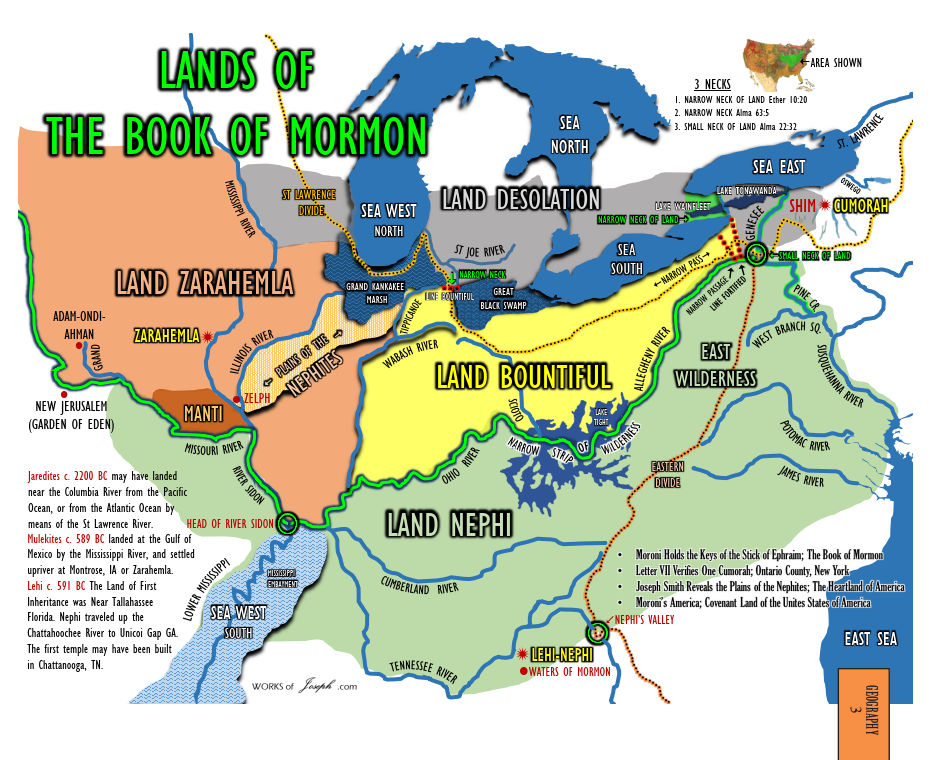
Consider the following proposed Book of Mormon map from Neville’s book, Moroni’s America – Maps Edition:
Moroni's America - Maps Edition, map 3 Lands of the Book of Mormon
If Neville is going to take his “M2C” opponents to task for creative interpretations of words, then Neville himself should also have to explain his own peculiar definitions:

  • In Neville-speak, “sea west” really means two different seas, one in the north and one in the south, both of which are east of the Nephite capital city of Zarahemla.
  • In Neville-speak, “sea east” really means two different seas, one to the north and one to the south.
  • In Neville-speak, “sea south” really means the sea that’s north of almost all Book of Mormon lands.
  • In Neville-speak, “wilderness” really means river (as we’ve discussed before).
  • In Neville-speak, “on the west…in the place of their fathers’ first inheritance” (where Lehi’s family landed) really means on the south of all other Book of Mormon lands, on the Gulf of Mexico.
  • In Neville-speak, “land northward” (where Cumorah was) really means land eastward, for, according to Neville’s map, Cumorah is 750 miles nearly due east (78°) from Zarahemla.

Neville’s proposed Book of Mormon is case study in distorting the facts to fit a predetermined conclusion. Neville is as guilty or more of doing everything that he accuses “M2C scholars” of doing.

—Peter Pan

* “M2C” is Jonathan Neville’s acronym for the theory that the Book of Mormon took place in Mesoamerica and that the hill Cumorah in the Book of Mormon is not the same hill in New York where Joseph Smith received the plates of Mormon.

Saturday, April 20, 2019

The illusion of scholarly engagement

Jonathan Neville is incredibly adept at repackaging the same simplistic argument into an infinite number of blog posts, but can he actually engage the published scholarship of “M2C intellectuals”?*

In his April 19, 2019, blog post, “Illusion of scholarship – Mormon’s Codex part 1,” he teases his readers with the possibility that he might actually give us something of substance. He begins:
After my [April 17th] post on the illusion of scholarship, people wanted specific examples.

Let’s start with Mormon’s Codex, which Professor Terryl Givens claims is “the high-water mark of scholarship on the Book of Mormon.” Foreword, Mormon’s Codex, p. xvi.
Despite his childish inability to resist including an image of the cover of Mormon’s Codex without overlaying it with an “M2C approved” stamp, this is a promising start. At last, perhaps we’ll finally get the takedown of the magnum opus of John L. Sorenson—Ph.D., University of California, Los Angeles, and Professor Emeritus of Anthropology at Brigham Young University—that we’ve been waiting for!

Neville continues:
Well, let’s start with Brother Givens. In the Foreword, he writes,

“Whether or not God spoke to Moses on Sinai, Jesus resurrected from the dead, or Paul wrote words given him by inspiration, no one doubts the Old World setting and ancient origins of the Old and New Testaments. Until such time as a preponderance of evidence provides comparable historical plausibility for the Book of Mormon’s ancient origin, no one can expect scholars to consider the book as anything other than a nineteenth-century cultural artifact. If such a time is to come, it will arrive in large measure through the efforts of John Sorenson, who has done more than any Latter-day Saint scholar to shift the terms of the Book of Mormon debates.”

This is the M2C or bust approach; i.e., you have to believe the Book of Mormon took place in Mesoamerica, and that the prophets are wrong about the New York Cumorah, or else you have to believe the Book of Mormon is fiction.
That’s Neville’s sole quotation from Mormon’s Codex.

Oh, Jonathan, you started with such promise and then you blew it! We were expecting some response to Sorenson’s claims, but instead all you did was give us a quote from the foreword and then proceed to misinterpret the only quote you gave us!

By claiming that Sorenson “has done more than any Latter-day Saint scholar to shift the terms of the Book of Mormon debates,” Givens clearly didn’t mean “shift it toward an ‘M2C or bust’ approach”; rather—as is clear from the context of the very paragraph you quoted—he shifted the debate from one of the Book of MOrmon being “a nineteenth-century cultural artifact” to it being an ancient document grounded in historical reality.

Now, that historical reality just so happens to be rooted in Mesoamerica, which is the reason Mormon’s Codex exists in the first place. Yes, we know that you disagree with that theory, and we can see from your blog post that you go on to repeat, for the umpteenth time, your unproven claims that believing that theory means “repudiat[ing] the teachings of the prophets” and causing loss of testimony among young Latter-day Saints, blah, blah, blah. But surely even you must admit that Professor Sorenson’s decades of research and publications—through actual, reputable publishers, not self-published outfits like CreateSpace {cough}—have all pointed toward his goal of grounding the Book of Mormon in historical reality.

Brother Neville, once again you’ve let us down.

Ah, well. At least you spelled “foreword” correctly in your blog post…unlike you did the book you edited, Moroni’s America – Maps Edition:

Moroni's America - Maps Edition: Forward & Acknowledgements

—Peter Pan

* “M2C” is Jonathan Neville’s acronym for the theory that the Book of Mormon took place in Mesoamerica and that the hill Cumorah in the Book of Mormon is not the same hill in New York where Joseph Smith received the plates of Mormon.

Sunday, March 24, 2019

When prophets testify but Neville doesn’t believe them

According to nearly every one of his blog posts, Jonathan Neville’s primary concern is that Latter-day Saints know “what the prophets and apostles have always taught about the New York Cumorah.” He believes that many LDS scholars are part of what he calls “the M2C* citation cartel,” a “fifth column” that “rejects the teachings of the prophets and apostles” about Cumorah.

Since accepting the teachings of prophets and apostles about Book of Mormon geography is apparently important to Neville, certainly he would see these teachings of apostle (and later Church president) Spencer W. Kimball of being of prime importance:
Not long before the birth of Christ, a great man by the name of Hagoth left continental America with colonies of people. He “went forth and built him an exceedingly large ship…and launched it forth into the west sea.… And behold, there were many of the Nephites who did…sail forth with much provisions, and also many women and children; and they took their course northward.…”

And the next year: “This man built other ships, And the first ship did also return, and many more people did enter into it;…and set out again to the land northward. And it came to pass that they were never heard of more…And…one other ship also did sail forth….” (Alma 63:5–8.)

It has been thought by many people that they went to the Pacific islands. And the scripture would so indicate:

“But great are the promises of the Lord unto them who are upon the isles of the sea; wherefore as it says isles, there must needs be more than this, and they are inhabited also by our brethren.” (2 Nephi 10:21.)

Elder [Matthew] Cowley and I visited some of these peoples on the “isles of the sea” and found them developing and progressing and doing well.

In 1976, when he was President of The Church of Jesus Christ of Latter-day Saints, Spencer W. Kimball told the saints in Samoa:
It seems to me rather clear that your ancestors moved northward and crossed a part of the South Pacific. You did not bring your records with you, but you brought much food and provisions. And so we have a great congregation of people in the South Seas who came from the Nephites, and who came from the land southward and went to the land northward, which could have been Hawaii. And then the further settlement could have been a move southward again to all of these islands and even to New Zealand. The Lord knows what he is doing when he sends his people from one place to another. That was the scattering of Israel. Some of them remained in America and went from Alaska to the southern point. And others of you came this direction.

President Joseph F. Smith, when president of the Church, said to the [Maori] people of New Zealand, “I would like to say to you brethren and sisters from New Zealand, you are some of Hagoth’s people, and there is No Perhaps about it!” He didn’t want any arguments about it.

So here we have the President of the Church, the prophet and seer of the Lord, testifying that the saints in Samoa and the other Pacific Islands were descendants of Hagoth, the shipbuilder described in the Book of Mormon. And President Kimball also quoted another president of the Church, Joseph F. Smith, who said “there is No Perhaps about it!” Therefore, according to President Kimball, there should be no arguments about where Hagoth went or who his descendants are.

So, does Jonathan Neville believe the prophets and apostles? It seems not.

This image is an extract from Moroni’s America – Maps Edition, a collection of maps edited by Jonathan Neville, based on his earlier book, Moroni’s America: The North American Setting for the Book of Mormon. Map 73 envisions Hagoth’s travels from the perspective of the “Heartland” Book of Mormon geography, of which Neville is an enthusiastic proponent:


Jonathan Neville’s fantasy map of Hagoth’s travels (Alma 63:5–8)

According to Neville, Hagoth built his ships at the south end of Lake Michigan (one of several “sea wests,” per his maps) and sailed north. From there he sailed up St. Marys River—which includes rapids that vessels larger than canoes could not pass until locks were built in 1855—into Lake Superior. Neville’s map also indicates Hagoth could have sailed east to Lake Huron (the “sea north,” which is east of the sea west) into Georgian Bay and then up an unnamed river. (From its position on the map, it appears to be the French River, which runs sixty-eight miles upstream, through numerous falls and rapids, to Lake Nipissing.)

Setting aside, for the moment, the impossibility of Hagoth’s “exceedingly large” ships navigating the rivers that flow between and into the Great Lakes, how would Hagoth have exited this freshwater system and traveled to Hawaii and the Pacific Islands? He hardly could have sailed from Lake Huron to Lake Erie, and sailing from Lake Erie to Lake Ontario and the St. Lawrence River would have required him to go over Niagra Falls! (The Welland Canal, which allows ships to bypass the falls, wasn’t completed until 1829.)

I’m curious to know how Neville reconciles his fantasy map with the tesimonies of two prophets of the Church. Does he accept their teachings or not? His maps don’t seem to indicate that he does.

—Peter Pan

* “M2C” is Jonathan Neville’s acronym for the theory that the Book of Mormon took place in Mesoamerica and that the hill Cumorah in the Book of Mormon is not the same hill in New York where Joseph Smith received the plates of Mormon.

Saturday, October 24, 2020

Those who live in glass houses, pt. 8

(Part eight of a series.)

Jonathan Neville writes:
In Joseph Smith’s translation of the Book of Mormon, there are zero accounts of people building massive stone temple, pyramids, or other structures. Yet the M2C* citation cartel has retranslated the text to describe these and other features of Mayan culture.
Setting aside his misrepresentations of Mesoamericanist arguments for a moment, Neville is in no position to criticize “M2C” Book of Mormon believers on this matter when his own writings on the Book of Mormon are filled with conjecture and downright fantasy about the Nephites and Lamanites.

Here are just a few examples from his book Moroni’s America. (Page numbers here refer to the Moroni’s America – Maps Edition volume he edited.)
Jonathan Neville's Lands of the Book of Mormon fantasy map
Jonathan Neville’s fantasy map of the Book of Mormon
  • According to Neville, the term “wilderness” means “river,” and the “narrow strip of wilderness” was “a water barrier that acted as a border—effectively a fence.” (pp. 2, 9)
  • According to Neville, the Book of Mormon’s references to the “narrow pass,” “narrow passage,” “narrow neck,” “narrow neck of land,” and “small neck of land” were not references to a single, narrow passage in a narrow neck of land, but five different passes, passages, and necks spread out across a distance of nearly 500 miles. (p. 4)
  • According to Neville, the sea west was actually two seas, one south of Nephite lands (the Mississippi River delta) and one northeast of Nephite lands (Lake Michigan). (pp. 12–13)
  • According to Neville, the narrow neck between the land Bountiful and the land of Desolation was a passage between the Grand Kankakee Marsh and the Great Black Swamp. Neither the terms marsh nor swamp appear anywhere in the Book of Mormon. (p. 16)
  • According to Neville, Lehi’s prophecy that the Lord “will take away from [the descendants of the Lamanites] the lands of their possessions, and he will cause them to be scattered and smitten” (2 Nephi 1:10–11) was fulfilled “at the beginning of the 1830s, [when] nearly 125,000 Native Americans” were forced the by federal government of the United States to relocate to modern-day Oklahoma, Kansas, and Nebraska. (p. 29–30) Neville ignores the important context of Lehi’s prophecy, written by Nephi in the preceding chapter: “The Lord God will raise up a mighty nation among the Gentiles, yea, even upon the face of this land; and by them shall our seed be scattered. And after our seed is scattered the Lord God will proceed to do a marvelous work among the Gentiles, which shall be of great worth unto our seed.” (1 Nephi 22:7–8; emphasis added). Nephi informs us that the scattering of the descendants of the Lamanites will take place before the Lord’s “marvelous work” in restoring the gospel to the earth—in other words, prior to the 1830s. Lehi’s prophecy, therefore, cannot refer to the Trail of Tears.
  • According to Neville, the peoples of the Book of Mormon used rivers (which are wildernesses?) to travel extensively throughout their lands. (pp. 37, 38, 40, 88, 89) There is not a single account in the Book of Mormon of anyone traveling by boat using rivers.
  • According to Neville, Hagoth the shipbuilder sailed his “exceedingly large ship” (Alma 63:5) between the Great Lakes and eventually out the St. Lawrence River to the Atlantic Ocean. (p. 73) Before the modern invention of locks, neither the rivers and rapids that connect the Great Lakes nor the St. Lawrence River could not be navigated by boats of any size.
  • According to Neville, the Nephites fortified Bountiful (Helaman 4:7) by building a massive earth-and-wood wall from Lake Michigan, down into southern Ohio,and then up to western New York. (p. 75) This wall would have been nearly 600 miles long. Needless to say, there is absolutely zero archaeological evidence of such an enormous structure.
  • According to Neville, the Nephites had “lambs, sheep, [and] rams,” which they sacrificied according to the law of Moses. (p. 85) Sheep—domesticated or wild—did not exist anciently in the eastern part of North America; they were introduced to the continent by the Spaniards. Sheep are mentioned twenty-five times in the Book of Mormon, all but once in a metaphorical context. The single passage that refers to the existence of sheep was during Jaredite times (Ether 9:18); the Nephites are never described as possessing sheep, nor using them for sacrifice.

Despite these and many other inaccuracies in Neville’s Book of Mormon claims, he feels free to criticize believers in a Mesoamerican setting for the Book of Mormon for things they never claimed in the first place.

Glass houses, indeed.

—Peter Pan

* “M2C” is Jonathan Neville’s acronym for the theory that the Book of Mormon took place in Mesoamerica and that the hill Cumorah in the Book of Mormon is not the same hill in New York where Joseph Smith received the plates of Mormon.

Saturday, January 1, 2022

Neville-Neville Land 2021 year in review

2021 Moroni's America map2021 was the third year of operation for this humble blog. This year we published 72 posts—not including this one, which I was uanble to publish before the end of the year—examining the heterodox beliefs and assertions of Jonathan Neville and his comrades in the Heartland Book of Mormon movement.

Among the most significant developments this year, I would include the following:


In keeping with tradition, here are the top ten Neville-Neville Land posts for 2021 by number of views:

  1. Heartland research director: “The Church is off course” (January 28, 2021) [This was, by far, the most popular post this year, with more than twice as many views as the next-most-viewed post.]
  2. Those who live in glass houses, pt. 12 (March 10, 2021)
  3. Elder Gerrit W. Gong: “Father Lehi’s faithful descendants” live “in Latin America” (April 3, 2021)
  4. Heartlanders push back against Rian Nelson’s nutty conspiracy theories (March 16, 2021)
  5. Rian Nelson, the Heartland hoax, and conspiracy theories (January 20, 2021)
  6. Rian Nelson rejects charges of Heartlander apostasy (July 21, 2021) [This post had the most comments this year.]
  7. The desolate Heartland theory (February 11, 2021)
  8. The identity of Peter Pan, and other issues Jonathan Neville is wrong about (April 8, 2021)
  9. Oliver Cowdery and Lehi’s landing site (January 14, 2021)
  10. Someone should really bring Jonathan Neville up to speed (March 24, 2021)

Sadly, I see little evidence that Jonathan Neville will retreat from his extremist views in the coming year and bring himself more in line with the teachings of the prophets regarding the Book of Mormon and how the Prophet Joseph Smith translated it. I hope I’m wrong about this, though.

—Peter Pan

Wednesday, May 29, 2019

Has the location of Cumorah really been revealed? An apostle says no.

In my last post, I discussed Jonathan Neville’s two-column list of those who purportedly believe the hill Cumorah of Mormon 6:6 is in New York versus those who believe it’s in Mesoamerica.

Neville’s “New York” list includes Church presidents, apostles, and other general authorities, while his “southern Mexico (M2C)*” column lists scholars, academics, and authors. His point—one that he makes over, and over, and over—is along the lines of “the prophets have spoken, so you can side with them or the disbelieving scholars who are leading the Church astray.”

What Neville fails to note is that not one apostle or prophet has directly stated that the location of Cumorah has been revealed by God, and some have expressed doubts about the New York location.

For example, Elder John A. Widtsoe, an apostle and member of the Quorum of the Twelve, wrote an article entitled “Is Book of Mormon Geography Known?” for the July 1950 issue of the Improvement Era, the Church’s official magazine. In it he stated:
As far as can be learned, the Prophet Joseph Smith, translator of the book, did not say where, on the American continent, Book of Mormon activities occurred. Perhaps he did not know.
Elder Widtsoe’s comment is most interesting, because Jonathan Neville is certain that Joseph Smith knew where the Book of Mormon took place, yet a senior apostle of the Lord freely conceded that “perhaps” Joseph ”did not know” where it happened.

Elder Widtsoe continued:
However, certain facts and traditions of varying reliability are used as foundation guides by students of Book of Mormon geography.

First, it is known by revelation that Adam, the father of the human race, lived in or near the territory now known as the state of Missouri. This has no bearing on Book of Mormon geography, since it deals with a period long before the coming of Book of Mormon people to America.
Again, Elder Widtsoe’s statement that the location of Adam has “no bearing on Book of Mormon geography” is at odds with Jonathan Neville’s view (and the views of others who promulgate the Heartland hoax). Neville’s book, Moroni’s America – Maps Edition, repeatedly makes a point of noting the location of Adam-ondi-Ahman and implying the importance of its proximity to Neville’s proposed Book of Mormon lands. (See maps 3, 4, 23, 87, 93, 122, 126, 138.)
Second, on the journey into northwestern Missouri, led by the Prophet, the skeleton of a large man was uncovered near the Illinois River. Joseph Smith said it was the remains of a white Lamanite named Zelph, a leader among this people. This is not of much value in Book of Mormon geographical studies, since Zelph probably dated from a later time when Nephites and Lamanites had been somewhat dispersed and had wandered over the country.
Yet again, Neville is at odds with an apostle: For Heartlanders, Joseph’s statement regarding Zelph is one of three key points in determining the geography of the Book of Mormon (the other two being a New York Cumorah and Zarahemla on the Mississippi River). Yet Elder Widtsoe explained that the Zelph account “is not of much value in Book of Mormon geographical studies” due to the dispersing of Book of Mormon peoples from the place Lehi landed.

Next we come to what may be the most important point in Elder Widtsoe’s article:
Third, the hill from which the Book of Mormon plates were obtained by Joseph Smith is definitely known. In the days of the Prophet this hill was known among the people as Cumorah. [Widtsoe cited History of the Church 1:15.] This is a fixed point in Book of Mormon later history. There is a controversy, however, about the Hill Cumorah—not about the location where the Book of Mormon plates were found, but whether it is the hill under that name near which Nephite events took place. [He cited Mormon 6:2, 6; 8:2; Ether 15:11.] A name, says one, may be applied to more than one hill; and plates containing the records of a people, sacred things, could be moved from place to place by divine help.

However, the hill known today as Cumorah in northern New York is a fixed, known point.
According to Jonathan Neville, “the prophets and apostles have always taught about the New York Cumorah,” yet here we have John A. Widtsoe, an apostle and senior member of the Twelve, telling us that there exists a “controversy” regarding this point and admitting that the name “may be applied to more than one hill” and the plates may have been moved after Moroni’ death.

This is quite remarkable, and an interesting blow to Neville’s most important theory.

For his fourth point, Widtsoe included a purported statement by Joseph Smith that “has been very generally accepted by the Church” that Lehi and his party “landed on the continent of South America, in Chile, thirty degrees, south latitude.” However, Widtsoe noted that “much doubt has been cast upon the reliability of this statement, since diligent search has failed to trace it to the Prophet.”

Widtsoe continued:
Fifth, a statement from the days of Joseph Smith, seldom quoted, bears on this subject. In the Times and Seasons, 1842, Zarahemla, a great Book of Mormon city, is partly identified with the ruins of Quirigua, spoken of in [John L.] Stephens’ great book Incidents of Travel in Central America, Chiapas and Yucatan. The article in the Times and Seasons positively stated that Zarahemla, while not necessarily where the Quirigua ruins now stands, was in “this land.” This seems to place many Book of Mormon activities in that region. The interesting fact in this connection is that the Prophet Joseph Smith at this time was editor of the Times and Seasons, and had announced his full editorial responsibility for the paper. [He cited Times and Seasons 3:710.] This seems to give the subjoined article an authority it might not otherwise possess.
Elder Widtsoe then proceeded to quote from the very Times and Seasons article that Jonathan Neville argues was a fraudulent attempt by the dastardly Benjamin Winchester to throw Joseph Smith and his prophetic knowledge of Book of Mormon geography under the bus. A member of the Quorum of the Twelve Apostles believed and taught that Joseph Smith believed that Zarahemla and the Book of Mormon were in Central America, but Neville apparently doesn’t believe this teaching.

Whom should we believe, Brother Neville? You, or an apostle of the Lord?

Elder Widtsoe then summarized his earlier points:
They who work on the geography of the Book of Mormon have little else than the preceding approaches with which to work, [namely]: that Nephites found their way into what is now the state of Illinois; that the plates of the Book of Mormon were found in a hill in northwestern New York State; that a statement exists of doubtful authenticity that Lehi and his party landed on the shore of the land now known as Chile; and that under the Prophet’s editorship Central America was denominated the region of Book of Mormon activities.
I note with interest that Elder Widtsoe did not mention in his “approaches with which to work” the risible Heartlander claim that D&C 125:3 revealed the ancient location of the Nephite city of Zarahemla to be in Iowa, across the Mississippi River from modern-day Nauvoo, Illinois. (And no other prophet or apostle has made this connection, either.)

Contrary to what Neville continually persists in asserting, there is no revealed geography of the Book of Mormon, including the location of the hill Cumorah that appears in the pages of that book of scripture. Elder Widtsoe’s published statements support that.

—Peter Pan

* “M2C” is Jonathan Neville’s acronym for the theory that the Book of Mormon took place in Mesoamerica and that the hill Cumorah in the Book of Mormon is not the same hill in New York where Joseph Smith received the plates of Mormon.

Sunday, September 15, 2019

Those who live in glass houses, pt. 3

(Part three in what appears to becoming a series. See Part 1 and Part 2.)

On September 15, 2019, Jonathan Neville again attacked Daniel Peterson’s publication, Interpreter: A Journal of Latter-day Saint Faith and Scholarship:
As we’ve seen in several examples on this blog, so-called “peer review” for The Interpreter [sic] is little more than “peer approval.” Otherwise the obvious errors of fact and logic that we’ve observed would not have gotten through to publication.
It take shipping container full of chutzpah for Neville to make this claim, considering the overwhelming errors in fact, logic, exegesis, history, science, and even grammar, spelling, and punctuation that are found in his own publications.

Notable examples of this include his blogs (this site has now published 114 responses to what he’s written online), his book Moroni’s America – Maps Edition (which is full of spelling errors and fantastic leaps of logic), and his coauthored Annotated Edition of the Book of Mormon (which Stephen O. Smoot exposed as being full of “forgeries, unprovenanced artifacts, and pseudo-archaeology; misrepresentations of historical sources; parallelomania; unsubstantiated claims and arguments; [and] the abuse of DNA science”).

If you want to find abundant examples of “peer approval,” look no further than the publications produced by Neville and his colleagues in the Heartland Book of Mormon movement. Neither he nor anyone else involved in spreading that hoax have any formal training in the subjects on which they expound, and it shows in the numerous, continual errors in their materials.
Victorian glass house Jonathan Neville’s house, probably.
—Peter Pan

* “M2C” is Jonathan Neville’s acronym for the theory that the Book of Mormon took place in Mesoamerica and that the hill Cumorah in the Book of Mormon is not the same hill in New York where Joseph Smith received the plates of Mormon.

Tuesday, December 20, 2022

My reply to Rian Nelson of the FIRM Foundation

On December 18, 2022, Rian Nelson published a post about me on the FIRM Foundation blog. I responded to his post the next day with an open letter. Rian replied with a comment on this blog. The following is my reply to his comment.
Mr. Pan, I appreciate you responding to by blog. Just a few responses.
There’s no need for formalities. Please, call me Peter.
Calling the CES Map a “Fantasy Map” is accurate. It does not relate to any current geography in the world.
Come now, Rian; be honest. You use that term as a derogatory label. We both know it.

The name of the BYU Book of Mormon Conceptual Map explains its purpose and goal, and its website informs us that it was designed and prepared to give “a basic idea of approximate directions and theoretical relationships between various geographical features mentioned in the stories.” It is not a “fantasy map” like the one of Middle-earth created for J.R.R. Tolkien’s The Lord of the Rings trilogy. Calling it a “fantasy map” misrepresents the intent of the project. This is similar to how you and Jonathan Neville use terms like “SITH,” which has sinister origins. It’s an unfair practice that demonstrates that you and your associates are not acting in good faith.

I have always referred to your book, Moroni’s America – Maps Edition, by its full title. The least you can do is refer to the Book of Mormon Conceptual Map by its proper name.
There is not one scriptural quote about Joseph using a stone in a hat to translate, and there are at least 4 or 5 scriptures that say he used the two stones fastened to a breastplate.
Your argument is a non sequitur. There are many events in Church history that happened but are not mentioned in the scriptures. For example, Joseph Smith began the translation of the Book of Mormon in Harmony, Pennsylvania, where he and Emma and Oliver Cowdery struggled financially. David Whitmer invited them to come to his father’s home in Fayette, New York, where they would receive free room and board and also assistance with writing while Joseph translated. Joseph took David up on his offer, and they moved there in early June 1829. There is nothing about any of that in the scriptures—not in the Book of Mormon, not in Joseph’s revelations in the Doctrine and Covenants, not in the canonized portion of Joseph’s 1838 history that’s in the Pearl of Great Price. Therefore, according to your logic, Joseph either never moved to Fayette or he was not authorized by the Lord to do so.

Joseph, of course, did use the Nephite interpreters/Urim and Thummim to translate portions of the Book of Mormon, but he also used a seer stone. Martin Harris—who was Joseph’s scribe for a time, an eyewitness to the translation process, and one of the Three Witnesses—said that “the Prophet possessed a seer stone, by which he was enabled to translate as well as from the Urim and Thummim, and for convenience he then used the seer stone.” Either Martin was correct, or he was mistaken, or he was lying. The fact that so many other eyewitnesses to the translation (including Emma Smith, David Whitmer, Joseph Knight Sr., Elizabeth Ann Whitmer Cowdery, and others) also reported that Joseph used a seer stone indicates that Martin was neither mistaken nor lying. (Jonathan Neville’s “demonstration hypothesis” is nothing more than an ad hoc way to dismiss the overwhelming eyewitness testimony that doesn’t fit with his beliefs.)

There are many things that are not in the scriptures but are nonetheless true.
I have no problem with those of you who believe differently in the geography and the translation than I do, as we all have that freedom.
But you and your associates clearly do have “a problem with those of [us] who believe differently,” because you keep claiming that if we don’t agree with your beliefs, then we’re “rejecting the teachings of the prophets,” promoting anti-Mormon claims, causing a loss of faith leading to apostasy among members, and are responsible for a decline in growth of Church membership.

Until you and your collaborators stop making these false assertions, please don’t claim that you “have no problem” with those who don’t agree with you.
When people say we are a hoax, or an apostate sect, or we are critical of the Brethren, or say we think we are racially superior to some, those are incorrect and small statements.
I disagree. Jonathan Neville has repeatedly claimed that Church leaders and Church employees are censoring Church history, misleading members, and publishing anti-Mormon arguments. These statements (among many others) are clear evidence that he is promoting an apostate form of the restored gospel that is critical of the Brethren.

Your own racially charged statements about the people of Latin America are directly at odds with what the prophets have taught.

I think the evidence demonstrates that my assertions are correct. And as long as Jonathan Neville can claim that “M2C” is a hoax, then I think it’s only reasonable that I can make the same claim about the Heartland movement.
Let me rephrase when I called you a “small person”, and say your comments are small minded.
Thank you for rephrasing that.
I know The United States is the promised land foretold in the Book of Mormon, as the Lord chose it. He did not chose it because those who live here are better people, or because it is a more beautiful place than other parts of the world, but He chose it to be the place of the Restoration of the Gospel in the Latter-days. Why? Because He chose it!
First, your statement is an example of circular reasoning and is thefore logically fallacious.

Second, I also believe that the United States was set apart by God to be the cradle of the Restoration—not because the Book of Mormon teaches that but because Joseph Smith’s revelations do.

Certain statements in the Book of Mormon can be interpreted to be references to the United States, but most of them are so nonspecific that they could refer to other nations as well. For example, the prophecy of the “mighty nation” that would scatter Lehi’s descendants (1 Nephi 22:7–8) cannot refer to the United States because that scattering was prophesied to take place before the coming forth of the Book of Mormon, and the expulsion of the American Indian tribes from the Eastern United States didn’t take place until after the Book of Mormon had already been published. (I wrote about this here.) Likewise, President Ezra Taft Benson and Elder Mark E. Peterson both declared that the “choice land” prophecy in Ether 2:9–12 refers to the entire Western Hemisphere, not just the United States.
May the Lord bless you in sharing the love of Christ, as I will try and do a better job of doing so as well.
Thank you! I also hope the Lord blesses you in your righteous endeavors. I also pray that he will hinder me, you, and anyone else who tries to lead people away from the truth of the restored gospel and the teachings and authority of living prophets.

—Peter Pan 

Popular Posts

Search This Blog