For some time I’ve wanted to critique Jonathan Neville’s proposed geography of the Book of Mormon. This is the first in what I expect will be a series that will demonstrate his proposed geography is fundamentally at odds with the descriptions given in the text of the book itself.
The problem with Neville’s geographic theory, of course, is that he’s put the cart before the horse: He
presumes that the Book of Mormon took place in the “heartland” of the United States, based on his (undemonstrated) belief that the statements of prophets and apostles about the location of Cumorah were revealed by God and based on a strained interpretation of
D&C 125:3 that claims it reveals the location of the Book of Mormon city of Zarahemla. These two references are what Neville calls “two pins on the map” in his books,
Moroni’s America and
Moroni’s America – Maps Edition:
Because of these two incorrect starting points, Neville has to twist himself into knots to force the geography described in the Book of Mormon to align with his “pins.”
One particular failure of his geography came to me suddenly today while I was reading
Helaman 1:14–34. This passage describes the Lamanite invasion of Nephite lands that took place ten years after the end of the end of the great war with the Lamanites (
Alma 62:39). Under the command of the Mulekite dissenter Coriantumr, the Lamanite army “came down” (
Helaman 1:15) from the land of Nephi into the land of Zarahemla. The Nephites, torn apart by “so much contention and so much difficulty in the government,” were unprepared for the Lamanites’ attack, and Coriantumr easily took the Nephite capital city of Zarahemla (
Helaman 1:18–20).
Overconfident because of his easy victory over the Nephite capital, Coriantumr
did not tarry in the land of Zarahemla, but he did march forth with a large army, even towards the city of Bountiful; for it was his determination to go forth and cut his way through with the sword, that he might obtain the north parts of the land. And, supposing that their greatest strength was in the center of the land, therefore he did march forth, giving them no time to assemble themselves together save it were in small bodies; and in this manner they did fall upon them and cut them down to the earth. (Helaman 1:23–24)
Four times the text of Helaman 1 explains that Coriantumr and his Lamanite army marched through “the center of the land” from their homelands in the land of Nephi, then to Zarahemla, then to Bountiful (
1:24, 25, 26, 27). Coriantumr’s objective was to “obtain the north parts of the land” (
1:23), which is a reference to the former Jaredite lands that the Nephites called
Desolation.
Mormon had previously described the Nephites’ precarious position and their desperate need to keep the Lamanites from taking the lands in the north:
Now, the more idle part of the Lamanites lived in the wilderness, and dwelt in tents; and they were spread through the wilderness on the west, in the land of Nephi; yea, and also on the west of the land of Zarahemla, in the borders by the seashore, and on the west in the land of Nephi, in the place of their fathers’ first inheritance, and thus bordering along by the seashore. And also there were many Lamanites on the east by the seashore, whither the Nephites had driven them. And thus the Nephites were nearly surrounded by the Lamanites.
Nevertheless the Nephites had taken possession of all the northern parts of the land bordering on the wilderness, at the head of the river Sidon, from the east to the west, round about on the wilderness side; on the north, even until they came to the land which they called Bountiful. And it bordered upon the land which they called Desolation, it being so far northward that it came into the land which had been peopled and been destroyed, of whose bones we have spoken, which was discovered by the people of Zarahemla, it being the place of their first landing. (Alma 22:28–30)
At the time of Alma 22, the Lamanites occupied the land of Nephi, south of the land of Zarahemla (
Alma 16:6;
50:7), and many Lamanites also lived “on the west of the land of Zarahemla, in the borders by the seashore” (
Alma 22:28) and “on the east by the seashore.” “And thus,” Mormon explained, “the Nephites were nearly surrounded by the Lamanites” (
Alma 22:29). The Nephites occupied the center of the land of Zarahemla and held the strategic land of Bountiful, which was at the head of a “narrow pass” (
Alma 52:9) or “narrow neck” (
Alma 63:5) that led to the land northward. If the Lamanites had obtained the narrow pass, they would have had the Nephites surrounded, and would “have [had] power to harass them on every side” (
Alma 52:9).
Prior to the great Lamanite war, Nephite captain Moroni drove the Lamanites out of the the wilderness areas on the west and the east of Zarahemla (
Alma 50:7–12), giving the Nephites total control of the land of Zarahemla, from the sea west to the sea east. Ten years after the war, Nephite captain Moronihah “had supposed that the Lamanites durst not come into the center of the land, but that they would attack the cities round about in the borders as they had hitherto done” in the great Lamanite war (see
Alma 51:22–28), “therefore Moronihah had caused that their strong armies should maintain those parts round about by the borders” (
Helaman 1:26). In other words, Moronihah’s armies were in the west and east wilderness areas, along the west and east seashores. Because of this, captain Lehi was able to bring his army out of the wilderness and meet Coriantumr’s army in the center of the land before the Lamanites reached Bountiful, while Moronihah’s army also came out of the wilderness behind Coriantumr, surrounding the Lamanite army and defeating them (
Helaman 1:28–31). Moronihah “took possession of the city of Zarahemla again, and caused that the Lamanites who had been taken prisoners should depart out of the land in peace” (
Helaman 1:33).
Mormon’s descriptions of Nephite lands in the passages I’ve cited are clear and unambiguous. They were arranged something like this:
Jonathan Neville will certainly object that my general map looks a lot like all the other “
fantasy maps” of the Book of Mormon that he rejects.
But this arrangement is the only way to logically arrange Nephite lands so that they meet all the requirements of the passages cited above. Any proposed Book of Mormon map
must depict Nephite lands in such a way that that they meet four criteria:
- There were wilderness areas on the west and the east of the land of Zarahemla, the Nephite core.
- Beyond the west and east wilderness areas were seashores.
- The land of Bountiful was north of the land of Zarahemla.
- The land of Bountiful was a defensive point before the “narrow pass” or “narrow neck” that led to the land northward (Desolation).
That’s the
only way that Mormon could describe the Nephites as being “nearly surrounded by the Lamanites” (
Alma 22:29), as well as “nearly surrounded by water” (
Alma 22:32). There was no other avenue of escape for the Nephites—
they had to hold the land of Bountiful, or else the Lamanites would have had them completely hemmed in with no means of escape.
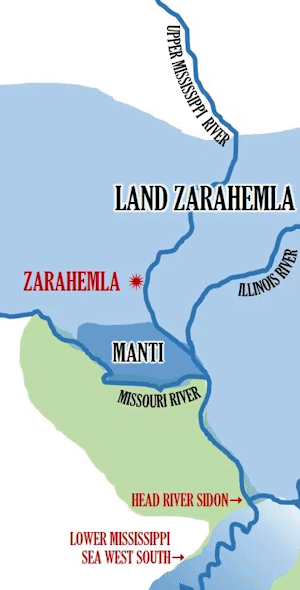
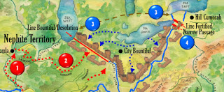
Now let’s look at Jonathan Neville’s map of Coriantumr’s invasion in Helaman 1:
Neville’s map—which mistakenly identifies itself as describing the action in
Helaman 2—
fails all four criteria.
There is no way, in Neville’s map, for the Nephites to be “nearly surrounded by the Lamanites,” as Mormon described them. Even if one grants all the lands south of the Missouri and Ohio Rivers were Lamanite territory, that would only box in the Nephites on two sides. The Nephites would have had numerous ways to escape invading Lamanite armies, including through modern-day Iowa, Wisconsin, and Minnesota, with another escape route through Michigan.
In Neville’s map, Bountiful is of no strategic value in keeping the Lamanites from getting to the north parts of the land (or
Desolation). The Lamanites could easily have done an end-run around Nephite lands through modern Pennsylvania, or crossed directly through Nephite lands in modern Indiana and Ohio and made their way north through Michigan, or traveled upriver along the Missouri to get north of the Nephites in Zarahemla, Iowa.
Neville tries to fix one of those three problems in his next map, number 75, in which he imagines that there was one continuous wood-and-earth fortification—a “Great Wall of Nephi,” if you will—between Lake Michigan (the “sea west”) and Lake Ontario (the “sea east”). This fantastic feat of construction—
for which there is no archaeological evidence whatsoever—would have been over
600 miles long. (
And Neville complains that BYU’s Virtual Book of Mormon is a “fantasy map”!)
Finally,
there is the problem of the west wilderness and the east wilderness on either side of the land of Zarahemla, with each each wilderness bordering a seashore. There’s simply no way that can work in Neville’s geography. In order to fit his geographical square peg into the round hole of the American Midwest, Neville has to distort the meanings of basic words multiple times. Sometimes he expects us to believe that these wilderness areas were
rivers (see map 9), even though the Book of Mormon tells us that people “lived in the wilderness” (
Alma 22:28). Other times he expects us to believe that rivers were
seas (see map 13, where he claims the lower Mississippi River was the sea west), except when
he needs them to be rivers (see map 12, where he claims the Mississippi River is the river Sidon). And as for Nephite and Lamanite lands being “nearly surrounded by water” (
Alma 22:32), he expects us to believe that means the Missouri and Ohio Rivers (see map 14), which were also wildernesses (per map 9).
Neville’s fantastic Book of Mormon geography is, in short, a mess. It makes no sense, doesn’t align with the book’s own descriptions of the lands, and requires us to define words in whatever way is convenient to Neville in an given passage.
—Peter Pan


